Details
| Home | About | Weather Details | Seismicity | Special Reports | Earthquake Energy Calculator | Earthquake Details | Station Equipment | Education | Links |
| Earthquake Details |


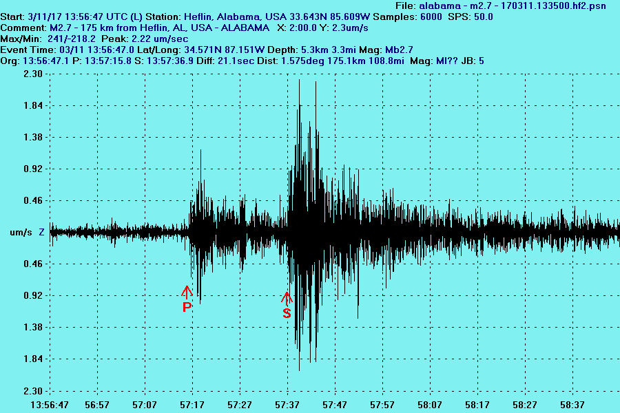
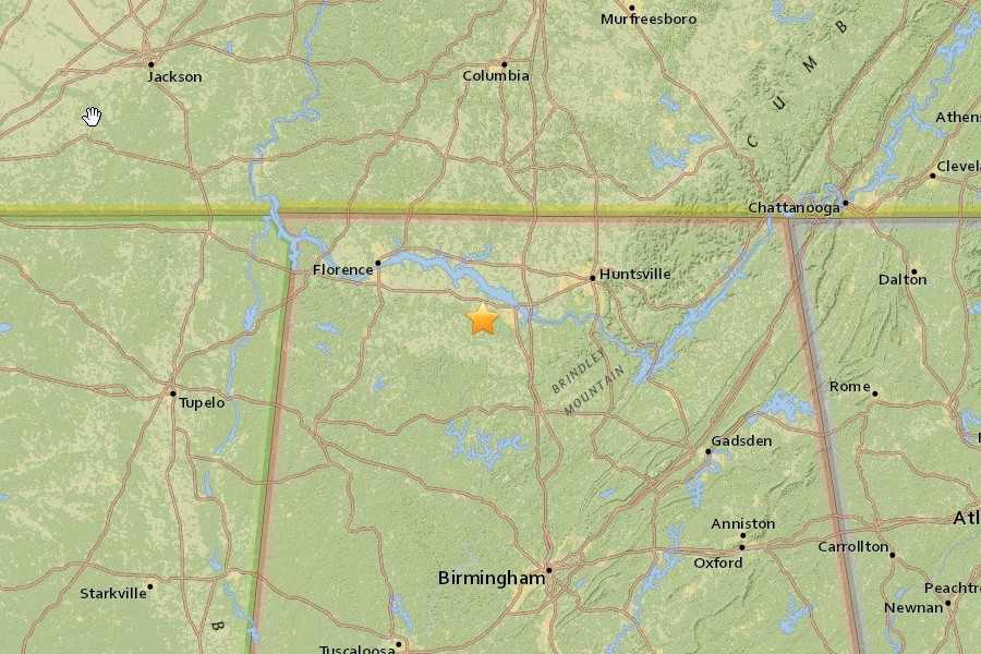
A small magnitude 2.6 earthquake occurred on 11 March 2017 at 13:56:47 UTC (7:56:47 am CST) with epicenter near Trinity
in northern Alabama, approximately 109 mi (175 km) from Heflin, Alabama. The quake had a
focal depth of 3.3 mi (5.3 km).
Northern and north-central regions of Alabama lie in
the Southern Appalachian Seismic Zone (SASZ), which roughly
follows the
Appalachian Mountains from southwestern Virginia into the northeastern corner
and central part of Alabama.
The USGS says that, “the Southern Appalachian
Seismic Zone is one of the most active earthquake zones in the eastern
United
States.” The SASZ has released moderate levels of seismic energy for many
hundreds of years. The tectonic setting
for the SASZ is crustal uplift/compression.
No active seismic faults are known to reach the surface in the SASZ, although
the
area is laced with many ancient faults that developed as the Appalachian
Mountains formed several hundred million years ago.
While many surface and
buried faults have been located in the region, numerous unknown smaller and
more deeply buried
faults remain undetected, and these all have an ongoing
potential for randomly located small-to-moderate earthquakes.
At the EarthAlabama seismic station at Heflin,
the initial P-type seismic body waves from the M2.6 quake were detected
29
seconds after the quake occurred, and slower S-type body waves were seen at +50 seconds following the
quake.
No observable surface (L-type)
waves from the event were seen at the Heflin seismic station.
More information about this event is available in the United States Geological
Survey report located at
https://earthquake.usgs.gov/earthquakes/eventpage/se60179996#executive
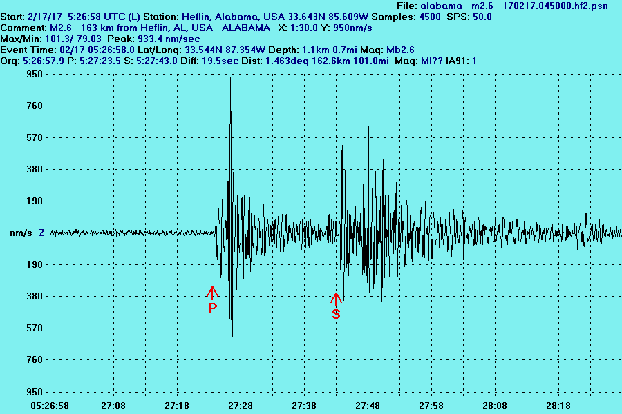
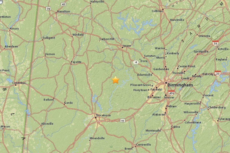
A very small magnitude 2.6 earthquake occurred on 17 February 2017 at 05:23:58 UTC (16 February 2017,
11:23:58 CST) in west-central Alabama, with
epicenter approximately 101 mi (163 km) from Heflin, Alabama.
The quake had a
focal depth of 0.7 mi (1.1 km).
Northern and north-central regions of Alabama lie in
the Southern Appalachian Seismic Zone (SASZ), which roughly
follows the
Appalachian Mountains from southwestern Virginia into the northeastern corner
and central part of Alabama.
The USGS says that, “the Southern Appalachian
Seismic Zone is one of the most active earthquake zones in the eastern
United
States.” The SASZ has released moderate levels of seismic energy for many
hundreds of years. The tectonic setting
for the SASZ is crustal uplift/compression.
No active seismic faults are known to reach the surface in the SASZ, although
the
area is laced with many ancient faults that developed as the Appalachian
Mountains formed several hundred million years ago.
While many surface and
buried faults have been located in the region, numerous unknown smaller and
more deeply buried
faults remain undetected, and these all have an ongoing
potential for randomly located small-to-moderate earthquakes.
At the EarthAlabama seismic station at Heflin,
the initial P-type seismic body waves from the M2.7 quake were detected
26
seconds after the quake occurred, and slower S-type body waves were seen at +45 seconds following the
quake.
No observable surface (L-type)
waves from the event were seen at the Heflin seismic station.
More information about this event is available in the United States Geological
Survey report located at
http://earthquake.usgs.gov/earthquakes/eventpage/us20008ke8#executive
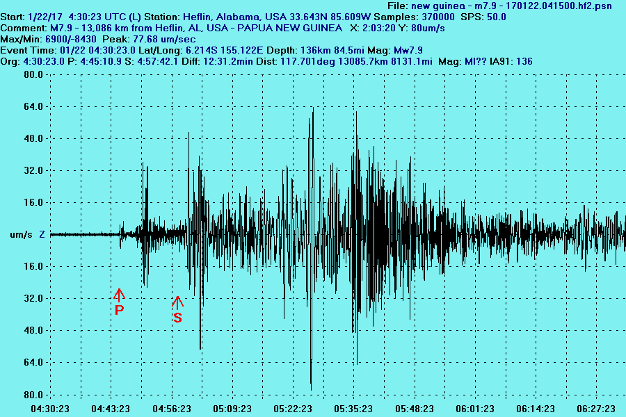
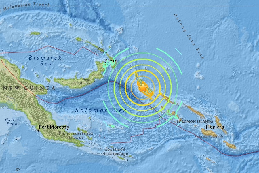
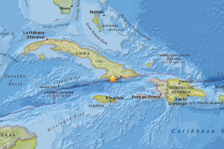
A magnitude 7.9 earthquake struck on 22 January 2017 at
04:30:23 UTC (10:30:23 pm CST 21 January) near Panguna in
the eastern Papua New Guinea region of the
western Pacific Ocean, at a location approximately 13,086 km (8131 mi)
from
Heflin,
Alabama. The quake had a focal depth of 136 km (85 mi). There were no immediate
reports of damages or injuries in the
epicentral area, though a tsunami
warning
was briefly issued for the region.
Eastern
Papua New Guinea is situated in
the area of the
South Solomon Trench and the Australia-Pacific tectonic plate
boundary
which
spans over 4000 km from the Sunda
(Java) trench in the west to the Solomon
Islands in the east. The boundary
is dominated by the general northward
subduction of the Australia plate.
Along the South Solomon trench, the
Australia plate
converges with the Pacific plate at a rate of
approximately 95
mm/yr towards the
east-northeast. Seismicity along the trench is
dominantly
related to subduction tectonics, and moderate-large earthquakes are common in the
region.
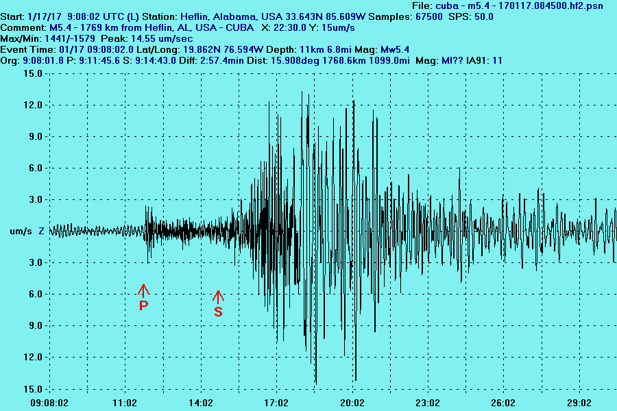
At Heflin, the initial seismic P-type body
waves from the
M7.9 event arrived approximately 18 minutes following the quake;
the
initial
arrival of
the slower S-type body waves was seen at +29 minutes; and the initial
observable surface waves began their arrival
about 54 minutes after the
quake had occurred in Papua New
Guinea. The surface
wave passage peaked at +56 minutes with a
maximum vertical ground displacement of 696
micrometers
(um) seen at the EarthAlabama seismic station.
The United States Geological Survey (USGS) report on this earthquake can be found at
http://earthquake.usgs.gov/earthquakes/eventpage/us10007uph#executive
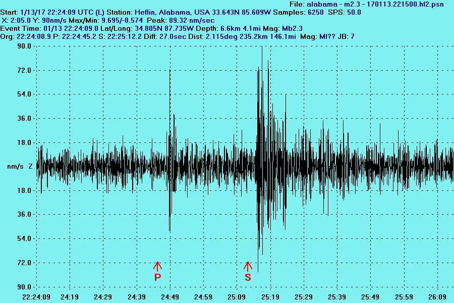
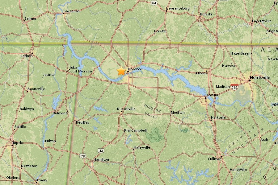
A very small magnitude 2.3 earthquake occurred
at 22:24:09 UTC (4:24 pm CST) in northwest Alabama near Florence,
with
epicenter approximately 146 mi (235 km) from Heflin, Alabama. The quake had a
focal depth of 4.1 mi (6.6 km).
Northern Alabama lies in
the Southern Appalachian Seismic Zone (SASZ), which roughly follows the
Appalachian
Mountains from southwestern Virginia into the northeastern corner
and central part of Alabama. The USGS says that,
“the Southern Appalachian
Seismic Zone is one of the most active earthquake zones in the eastern United
States.”
The SASZ has released moderate levels of seismic energy for many
hundreds of years. The tectonic setting for SASZ is
crustal uplift/compression.
No active seismic faults are known to reach the surface in the SASZ, although
the area is laced
with many ancient faults that developed as the Appalachian
Mountains formed several hundred million years ago.
While many surface and
buried faults have been located in the region, numerous unknown smaller and
more deeply buried
faults remain undetected, and these all have an ongoing
potential for randomly located small-to-moderate earthquakes.
At the EarthAlabama seismic station at Heflin,
the initial P-type seismic body waves from the M2.3 quake arrived after 40
seconds,
and slower S-type body waves were seen at +66 seconds following the
quake. No observable surface (L-type)
waves from the
event were seen at the Heflin seismic station.
More information about this event is available in the United States Geological
Survey report located at http://earthquake.usgs.gov/earthquakes/eventpage/se60171946#executive
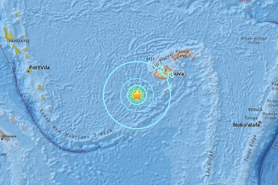
The southwestern
Pacific Ocean region is one of the most seisimically active areas of the world
due to high rates of
convergence between the Australia and Pacific plates.
Large earthquakes are common in this area due to subduction
tectonics. Across
the North Fiji Basin and to the west of the Vanuatu Islands, the Australia
plate is subducting eastward beneath
the Pacific plate at the North New
Hebrides trench. The Australia-Pacific plate convergence rates vary from 70 to
100 mm/year
along the Kermadec trench, to as much as 150 to 240 mm/year along
the Tonga trench.
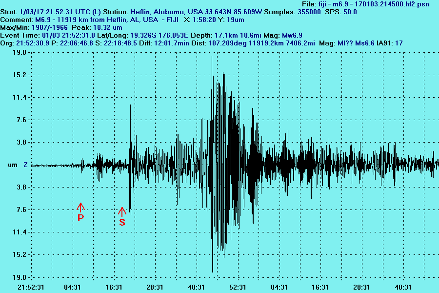
At Heflin, the initial seismic P-type body waves from the M6.9 event arrived approximately
10 minutes following the quake.
The initial arrival of the slower S-type body
waves was seen at +28 minutes, and the initial observable surface waves began
their arrival about 51 minutes after the quake had occurred in the Fiji region. The surface wave passage peaked
at +52 minutes with a maximum
vertical ground displacement of approximately 18 micrometers (um)
measured at
the EarthAlabama seismic station.
More information about this event is available in the United States Geological
Survey report located at
http://earthquake.usgs.gov/earthquakes/eventpage/us10007pj6#executive
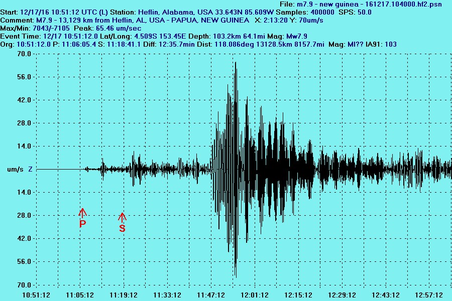
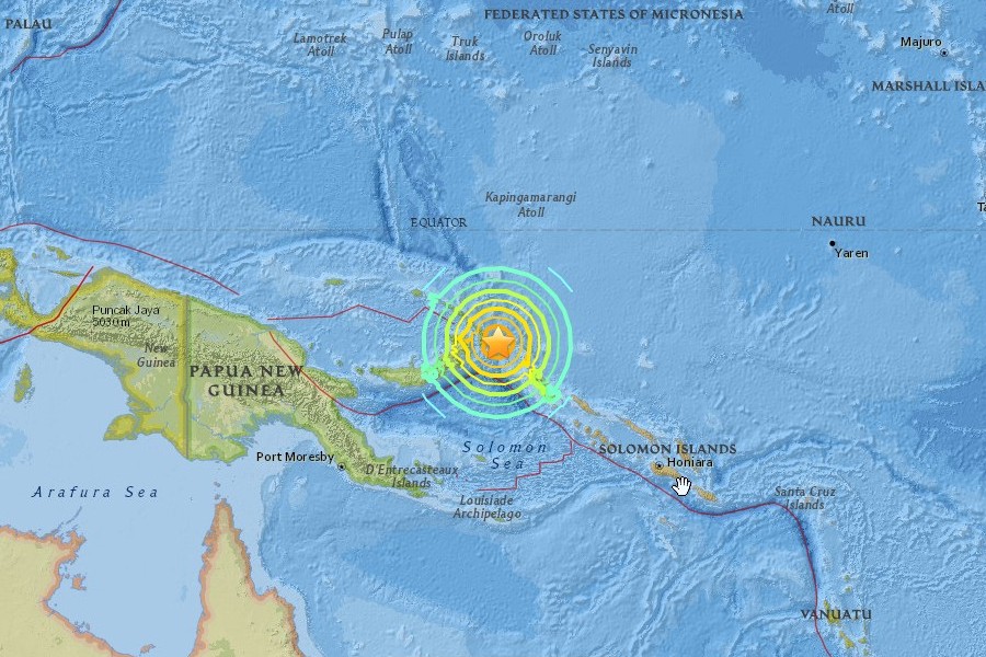
Papua
New
Guinea, M7.9, 17
December 2016
A magnitude 7.9 earthquake occurred on 17
December 2016 at
10:50:12 UTC (4:50:12 am CST) near Taron in eastern Papua New Guinea,
in the
western Pacific Ocean, at a location approximately 13,129 km (8158 mi)
from Heflin,
Alabama. The quake had a focal depth
of 103 km (64 mi). There were no immediate
reports of damages or injuries in the epicentral area, though a tsunami
warning
was issued for the region.
Eastern
Papua New Guinea is situated in
the area of the
South Solomon Trench and the Australia-Pacific tectonic plate boundary
which
spans over
4000 km from the Sunda
(Java) trench in the west to the Solomon
Islands in the east. The boundary is dominated by the general northward
subduction
of the Australia plate.
Along the South Solomon trench, the
Australia plate converges with the Pacific plate at a rate of
approximately 95
mm/yr
towards the
east-northeast. Seismicity along the trench is dominantly
related to subduction tectonics and large earthquakes are common in the
region.
At Heflin, the initial seismic P-type body
waves from the
M7.9 event arrived approximately 16 minutes following the quake; the
initial
arrival of
the slower S-type
body waves was seen at +28.5 minutes; and the initial
observable surface waves began their arrival about 56 minutes after the
quake had occurred in
Papua New
Guinea. The surface
wave passage peaked
at +64 minutes with a maximum vertical ground displacement of 236
micrometers
(um) measured
at the EarthAlabama seismic station.
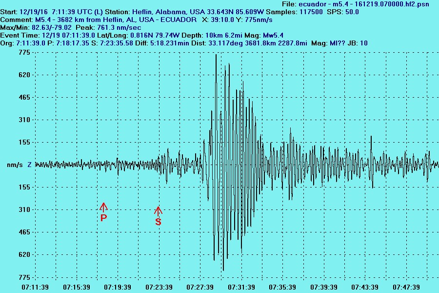
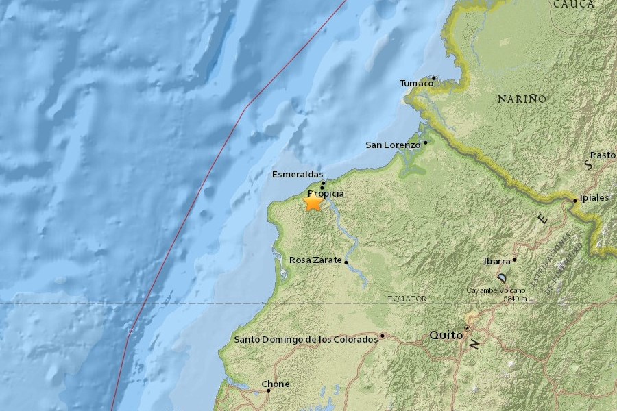
A moderate magnitude 5.4 earthquake
occurred on 19
December 2016 at 07:11:39 UTC (1:11:39 am CST) near Propicia in coastal
northwestern
Ecuador,at a location approximately 3,682 km (2,288 mi)
from Heflin,
Alabama. The quake had a focal depth of 10 km (6.2 mi). There were no
immediate
reports of injuries in the region, though some electrical power outages
were
reported in the epicentral area.
Coastal
Ecuador is located atop the South American Arc which extends over 7,000
km, from the Chilean margin triple junction offshore of
southern
Chile
to its intersection with the Panama fracture zone, offshore of the
southern
coast of Panama in Central America. The Arc marks the plate
boundary
between the subducting Nazca plate and the South America plate, where
the oceanic
crust and lithosphere of the Nazca plate begin their
descent into the
mantle beneath South America. Relative to a fixed South America plate,
the Nazca plate
moves slightly north of eastwards at a
rate varying from approximately
80 mm/yr in the south to approximately 65 mm/yr in the north. This
subduction
dramatically influences volcanic
activity, crustal deformation, and
earthquake occurrence all along the western edge of South America.
At Heflin, the initial seismic P-type body
waves from the
M5.4 event arrived approximately 8 minutes following the quake; the
initial
arrival of
the slower S-type body waves was seen at +12 minutes; and the initial
observable surface waves began their arrival about 16 minutes after
the
quake had occurred in Ecuador.
The
surface
wave passage peaked
at +17.5 minutes with a maximum vertical ground displacement of 3.5
micrometers
(um) measured at the EarthAlabama seismic station.
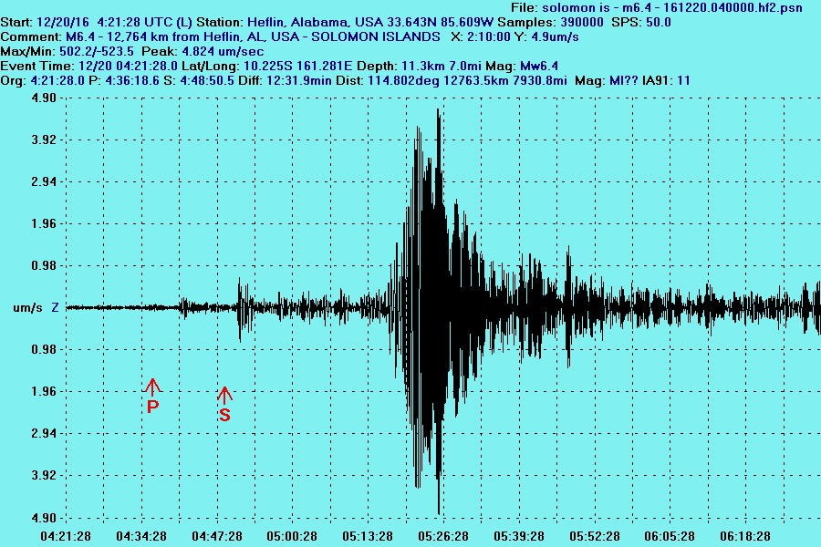
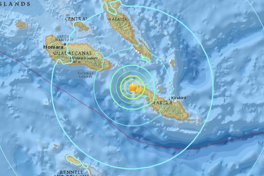
A moderately-strong magnitude 6.4
earthquake
occurred on 20
December 2016 at 04:21:28 UTC (10:21:28 pm 19 December)
near Kirakira in the Solomon Islands, at a location
approximately 12,764 km (7,931 mi) from Heflin,
Alabama. The quake occurred at a
focal depth of 11.3 km (7.0 mi). There were no immediate
reports of injuries in the region, and no tsunami warning was issued
from the event.
world
due to high rates of convergence between the Australia and Pacific
plates. Large earthquakes are common in this area of complex
interactions
between the plates, with most arising from subduction of the Pacific
plate at various angles beneath the Australia plate.
Convergence
rates vary in the region, from some 70-100 millimeters per year in the
southern-most parts of the area, to as much as
150-240 millimeters per
year in the north.
| Home | About | Weather Details | Seismicity | Special Reports | Earthquake Energy Calculator | Earthquake Details | Station Equipment | Education | Links |